
|
|
|
|
CONTACT
FLOOD HISTORY
PHOTO GALLERY
SYSTEM COMPONENTS :
FORECASTS:
PROJECT
SYSTEM COMPONENTS
OPERATIONS
FORECASTS
|
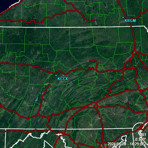
LOCALIZED RADAR
UPDATED EVERY 10 MINUTES
This doppler radar loop is provided directly by the Sunbury Municipal Authority. The radar loop updates every 10 minutes.
The colors represent different echo intensities (reflectivity) measured in dBZ (decibels of Z) durring each elevation scan. "Reflectivity" is the amount of transmitted power returned to the radar reciever. Reflectivity (designated by the letter Z) covers a wide range of signals (from very weak to very strong) So, a more convenient number for calculations and comparison, a decibel (or logarithmic) scale (dBZ), is used.
The dBZ values increase as the strength of the signal returned to the raday increases. The scale (left) represents dBZ values when radar is in precipitation mode (dBZ values from 5 to 75).
The scale of dBZ values is also related to the intensity of rainfall (right). Typically, light rain is occurring when the dBZ value reaches 20. The higher the dBZ, the stronger the rainrate. Depending on the type of weather occurring and the area of the U.S., forecasters use a set of rainrates which are associated to the dBZ values.
These values are estamates of the rainfall per hour, updated each volume scan, with rainfall accumulated over time. Hail is a good reflector of energy and will return very high dBZ values. Since
hail can cause the rainfall estimates to be higher than what is actually occurring, steps are taken to prevent these high dBZ values from being converted to rainfall.

Flood Operations Center
826 Hillside Road
Sunbury, Pennsylvania 17801
All contents © 2015 Sunbury Municipal Authority | site design: BLH Media